Dry Creek housing development site ‘will be inundated by 2100’
A 10,000-home government-backed development on the Dry Creek saltpans in Adelaide’s north faces a “very high” risk of flooding due to sea level rise from climate change, according to environmental experts and councils, prompting concerns about insurability and high infrastructure costs.

A view of the Dry Creek saltpans looking south towards the city. Photo: Tony Lewis/InDaily
The Malinauskas Government in February earmarked the Dry Creek saltpans – located around 12km north of the CBD between the Northern Connector and Salisbury Highway – for 10,000 new homes.
The growth area accounts for nearly 40 per cent of the 25,600 new homes the government wants to deliver by rezoning land in Adelaide’s northern and southern suburbs.
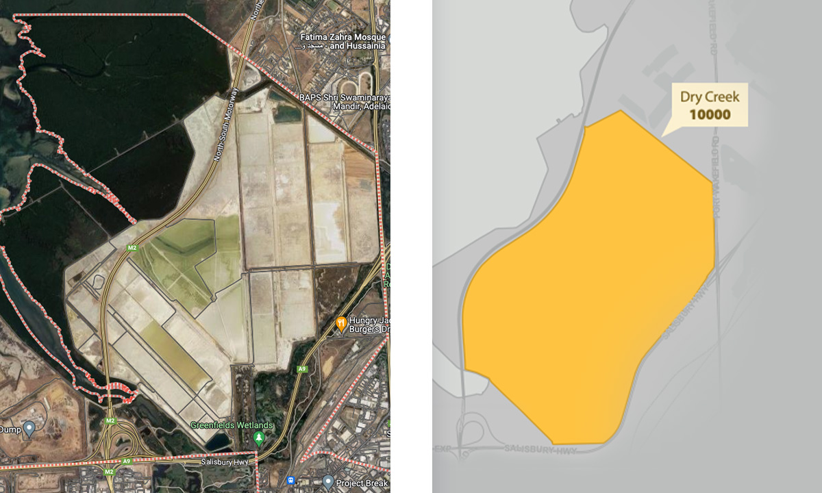
A map of the Dry Creek salt field area earmarked for development.
Planning Minister Nick Champion told a developers’ luncheon earlier this month that Dry Creek is “undoubtedly one of the biggest opportunities that South Australia has”.
But councils and environmental experts have raised concerns that the low-lying salt fields are not suitable for residential development.
The City of Campbelltown and City of Holdfast Bay have both told the Planning Commission that the 980-hectare site will be “inundated” by climate change-induced sea level rise.
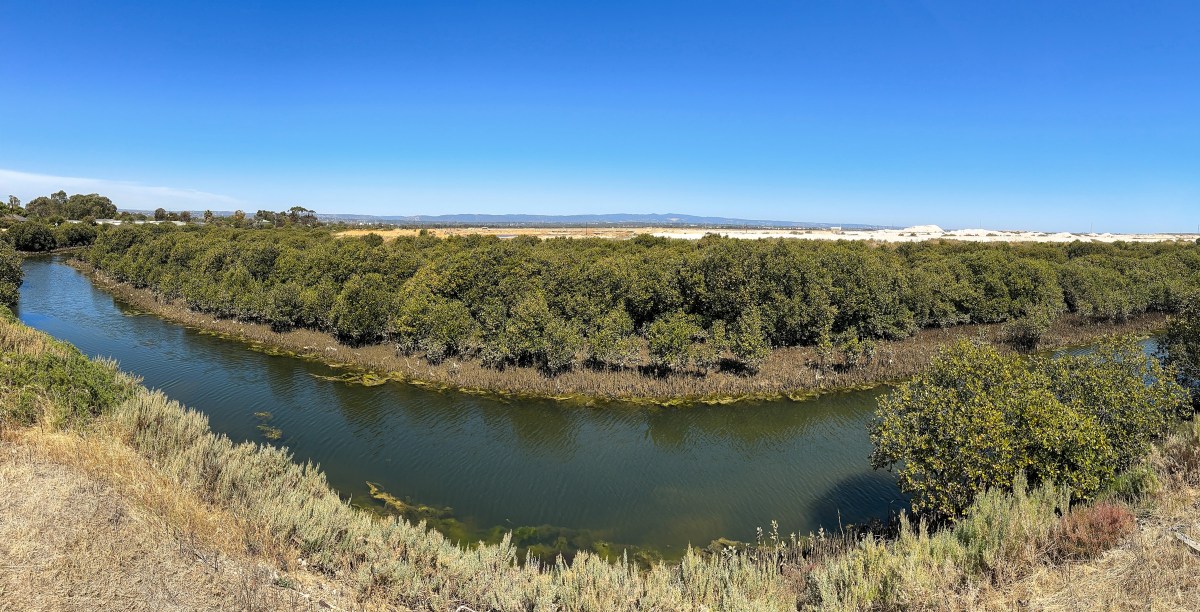
A view of the Dry Creek saltpans looking towards Port Adelaide. Photo: Tony Lewis/InDaily
“The proposed Dry Creek development area is already expected to be mostly under water in the highest tide events,” the councils submitted to the government’s Greater Adelaide Regional Plan (GARP) discussion paper last month.
“At the end of the Century, the entire site is expected to be inundated.
“Developing this site is likely to build in vulnerabilities and costs to both occupants and Governments.”
A City of Campbelltown spokesperson said their claims were based on publicly available mapping from Coastal Risk Australia, a service developed by geospatial firms FrontierSI and NGIS.
The site provides inundation maps for Australia’s coastlines in the year 2100 based on Geoscience Australia data and the Intergovernmental Panel on Climate Change (IPCC) Fifth Assessment Report.
The map shows the Dry Creek development area inundated in a high tide event if sea levels rise 0.84 metres by 2100, which the IPCC predicts with medium confidence.
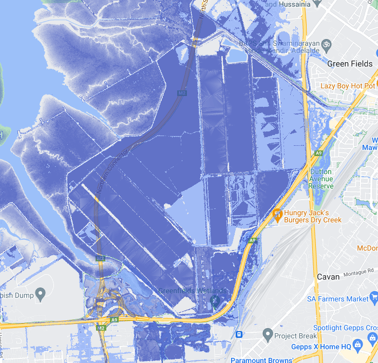
The Coastal Risk Australia map of Dry Creek in a high tide event in 2100, based on IPCC climate change data.
“The flooding risk is very high,” said Colin Pitman, a former City of Salisbury director who was involved in flood protection and managing the Salisbury wetlands for more than 20 years.
“The issue of long term sea level rise and tidal inundation is going to have to be addressed as part of the development, because sea level rise will cause inundation of the residential development beyond what it’s already been designed for.
“So, there’s got be very careful consideration to the way in which the development occurs.”
Pitman estimates the Dry Creek development area, which is also near natural breeding grounds for mosquitos, would be at risk of a flood event once every 50 years.
He said the low-lying land would have to be raised “significantly” to protect residents from flooding, requiring an engineering technique he said has not been tried in South Australia and would cost untold millions.
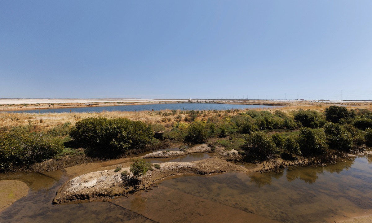
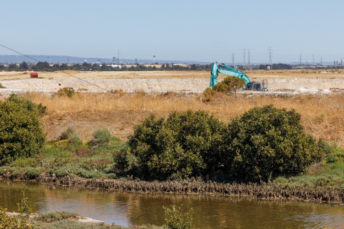
A mangrove-lined creek along the Dry Creek saltpan. Photo: Tony Lewis/InDaily
“If it’s going to be urbanised then it’s got to be designed properly to ensure residents don’t flood in the very long term – I’m talking about the next 100 to 200 years – and also that the ecology of the area is not affected by the urbanisation,” he said.
“The housing can develop there providing it is staged so the environmental component of the development actually occurs before the houses develop.
“It shouldn’t occur the other way around where the residential area establishes and then we think about later fixing up the stormwater and tidal water problems.”
Planning experts raised similar concerns about the Walker Corporation’s proposed 12,000 home satellite suburb, Riverlea, located around 20km north of Dry Creek near the Gawler River.
But Pitman said the Dry Creek area has a greater flooding risk. In his view, the development is feasible but should not be supported.
InDaily asked the Planning Minister whether the government had factored in climate change and flooding risk with the Dry Creek development.
In a statement, Champion replied: “Yes. The state government-owned land at Dry Creek is currently constrained by a low-lying profile.
“Any future development of this land will require significant fill to raise its elevation. Climate change and stormwater management will be considered in detail during project planning and any code amendment process.”
Asked if the state government has modelling on how this site will be affected by rising sea levels, Champion said: “Yes, the State Government has mapping, which informs the Hazard (Flooding) Overlays as part of the Code.”
Infrastructure, insurance cost concerns
The City of Holdfast Bay has told the Planning Commission it’s concerned about the insurance implications of the Dry Creek growth area.
It cited a 2019 Insurance Council of Australia estimate that the average clean-up costs for disaster-hit properties is around $50,000. The council said this meant the uninsured clean-up cost for a flood event in Dry Creek could reach $500 million.
“In deciding the location of new neighbourhoods… the climate conditions a century into the future need to be considered,” the City of Holdfast Bay told the Planning Commission in response to the GARP discussion paper.
“Planning authorities can choose to build in resilience for new neighbourhoods, or choose to build in vulnerability.”
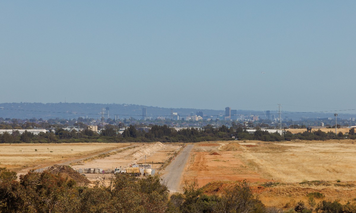
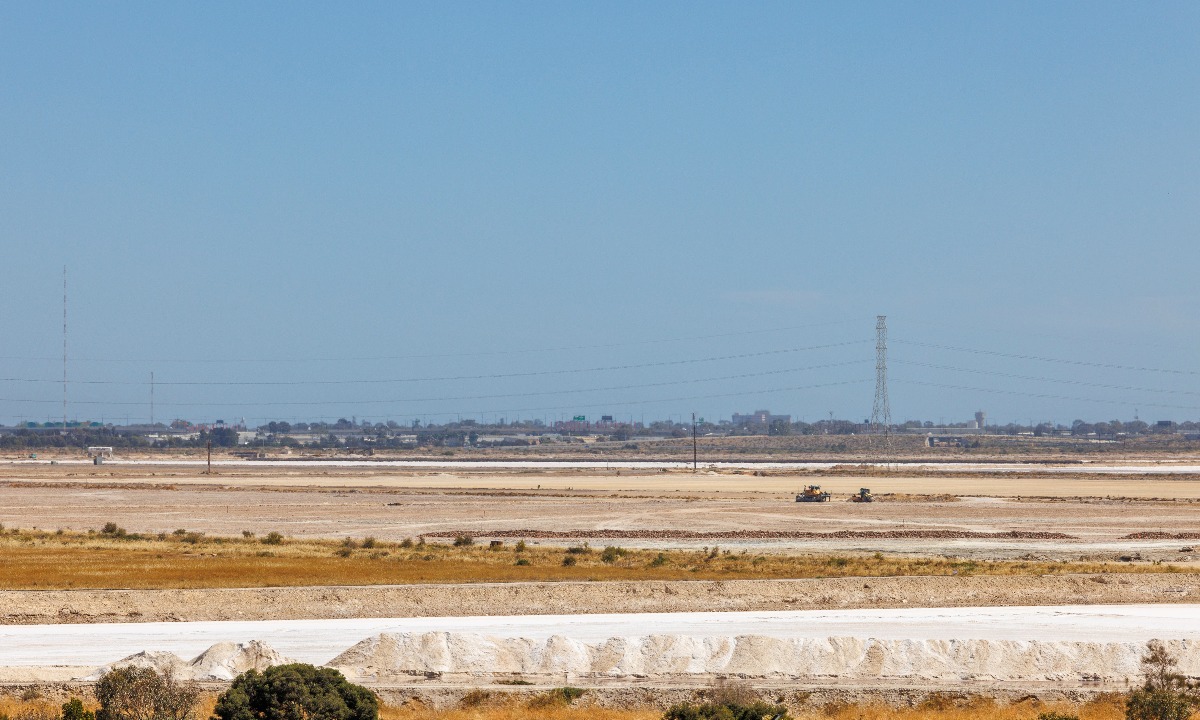
A view of the saltpans from Globe Derby Park, looking south towards the city. Photo: Tony Lewis/InDaily
The council said the GARP discussion paper does not properly account for the climate and health impacts of the government’s proposed growth areas, including Dry Creek.
“A current deficit of the GARP Discussion Paper is that it does not determine if houses in these growth areas will still be liveable, insurable, comfortable, healthy, affordable to live in, or regularly exposed to flood, and sea level rise risks,” the council said.
“Insurability is already being discussed at a national level and is already unachievable for many Australians.”
Dr Scott Hawken, director of landscape architecture and urban design at the University of Adelaide, said the Dry Creek area will require “extensive infrastructure and defensive works” to prepare it for housing.
“Is it feasible to make money from the development? Potentially, depending on the purchase price of the land,” Hawken said.
“Ongoing long term maintenance costs in the face of climate change is another question.”
Hawken co-authored a 2022 paper about climate adaptation for coastal landscapes which used the northern Adelaide region as a case study.
The paper suggested that urban development on the Dry Creek saltpans “will consume large quantities of resources for filling low lying land and also place additional pressure on coastal ecosystems, water security and drainage systems”.
“Long-term insurance from 50 to 100 years against sea level rise and climate-related impacts may be prohibitively high and render the development unfeasible unless realistic assumptions about flooding are built into the development,” the paper states.
Hawken told InDaily that the population of the new Dry Creek development – anticipated to be more than 20,000 people – would be better accommodated in new medium density housing in Port Adelaide.
Call for public transport solution
The Dry Creek saltpans started producing salt in the 1940s. Photo: Tony Lewis/InDaily
The City of Salisbury has asked the state government to plan for mass public transit to both the Dry Creek development and Riverlea.
The council estimates that the salt fields will take around 20-years to redevelop.
“Dry Creek will provide the next tranche of significant population growth for our council providing for approximately 10,000 dwellings,” the council said in its GARP submission.
“Detailed master planning for Dry Creek has yet to substantially commence and it is likely that the infrastructure and building costs will be substantial.
“The development of this land is likely to have a 20-year lifespan.”
The state government owns 397 hectares of land at Dry Creek while the rest is owned by Buckland Dry Creek.
The company, a subsidiary of the Jurkovic Group, reportedly shelved plans in 2022 for a 15,000 home development on the salt fields due to delays in rezoning the land.
The former owner of the land, the Ridley Corporation, also proposed housing estates on the salt pans in 2008 and 2013.
Planning Minister Champion told a parliamentary estimates committee in July that the government’s land agency, Renewal SA, is leading negotiations with the Buckland Dry Creek company.
He said the land would not be rezoned for housing until environmental investigations are completed.
“We acknowledge it is a complex site and it is going to be a challenge to bring it to market,” he said on July 5.
Asked if the Environmental Protection Agency had raised any issues about the land’s suitability for housing, Champion said: “It is more about the resolution of the salt mining issue.
“At the moment it is a salt mine that stretches right across the coastline, right up to Middle Beach where the pumps are and so, clearly, that will need remediation: the removal of salt and those sorts of issues.
“Renewal is consulting with government departments and the Buckland Dry Creek company about that.
“That is a process that has to be undertaken. It has to be undertaken carefully but, ultimately, once those remediation issues are dealt with then it is just like all the other remediation issues we deal with.
“That is what Renewal is set up to do: remediate land and bring it to market.”