In 1986 Robert Cheesman wrote a small book on the subject of “British new towns and associated settlements” titled Patterns in Perpetuity. His chapter on the foundation of Adelaide linked the design of the city to the utilitarians and Jeremy Bentham, in particular.
It also speculated on the nature of the model plan for the city provided by the Colonial Commission (and its antecedents in North America), opening the door for others to indulge in similar speculation. It encouraged me to learn more about Colonel William Light, the surveyor-general, who was given sole responsibility for locating the city and setting out the model plan on the selected ground.
My admiration for Light and his achievements deepened with understanding.
Viewed through a utilitarian prism, it became apparent that the final layout of the city responded brilliantly to instructions provided by the Colonial Commission and also demonstrated Light’s very considerable skills acquired as an intelligence officer in the Peninsular War in service under the Duke of Wellington. These enabled him to adapt the model plan provided with great practicality and sensitivity to topographical features. Those with knowledge of Wellingtonian battlefields will immediately recognise the comparable topography.
The surveyors’ camp was located near where the old Adelaide Gaol (a utilitarian panoptic pattern by Bentham) sits today. He viewed the site from the closest reference point where the Haymarket Hotel still stands on the corner of West and North Terraces – the starting point for the set-out line. One imagines the design process went something like this:
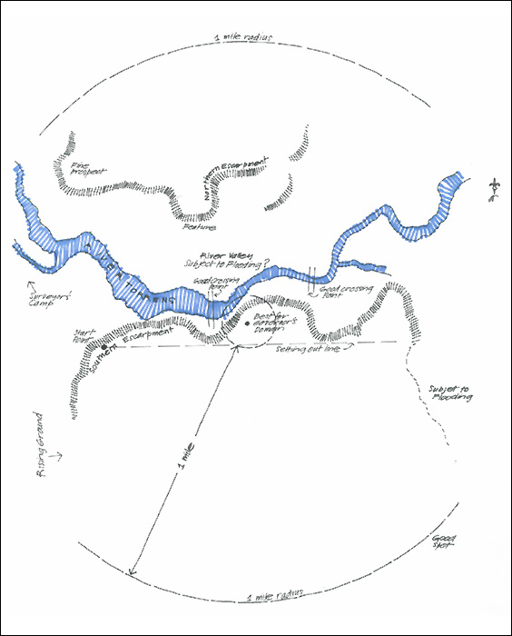
The mud map
Colonel Light is in a hurry and the colonists, led by Governor Hindmarsh, are demanding action from their camp in the dunes at Holdfast Bay. After almost a week of surveying the chosen site and while others in the survey party are preparing lunch on a hot summer’s day, Colonel Light sits under a gum tree and sketches out a mud map of the site chosen for the city, noting important features.
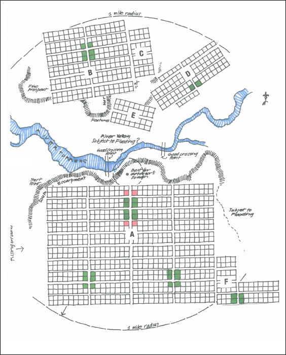
Settling on the best spot for the Governor’s domain, he decides that the entire city should fall within a radius of one mile from there and that the city should therefore sit on both sides of the river valley. He notes that an extra square will be needed north of the river valley for symmetry. He also notes that some very attractive land lies in the south-east corner on the southern side of the river. This corner will become known to colonials as “the wilderness”.
The model plan
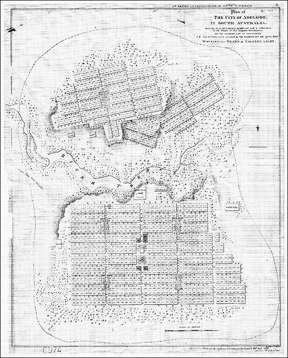
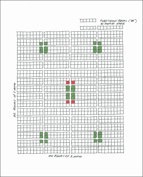
Colonel Light unclasps his map case and retrieves the model plan based on the plan for the city provided to him by the Colonial Commission in London. He is required to survey 1000 allotments of one acre for private sale. The way to create 1000 allotments with the greatest utility is by having 32 along each axis, making a total of 1024. Noting that extra allotments will be needed for public and government facilities, he has added another 18 acres to account for squares (38 acres), including for an additional square north of the river valley, and government buildings (4 acres) – 1042 allotments in all.
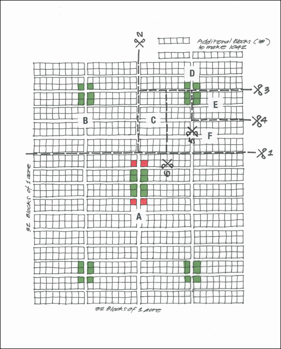
He attaches these extra acres to the top right-hand corner of the model plan and asks the exceptionally talented young Mr RG Thomas (a student of George Kingston, whom his parents claimed taught him nothing) for the scissors. Mr Thomas is to draw the first plan of the city under Light’s instructions in watercolour medium.
The first cut
Having in mind the various features of the land and marking a set outline along the southern side of the river, which amazingly approximates to east-west, Colonel Light confirms that the model plan will need to be fragmented if it is to fit within a one mile radius from the Governor’s domain. Being a man of action, he confidently cuts the model plan into two pieces.
Spreading the bits
Cutting off the top of the model plan so that the larger bottom part (a) aligns with the set-out line and fits south of the river within a one-mile radius, Colonel Light then halves the smaller upper section, locating one half (b) above the northern escarpment, aligning with its lower edge and more or less tangential to the circumference of the radius. The odd angle discrepancy from part (a) amuses him. Encouraged by this, he cuts the remaining half into four pieces (c, d, e and f). He adds one part (c) to part (b) and locates two others (d and e) at jaunty angles parallel to relevant sections of the river below. Observing that lunch is almost ready, he drops the last piece (f) in the good spot he noted – the “wilderness” of part (a). Five cuts in all.
A light trim
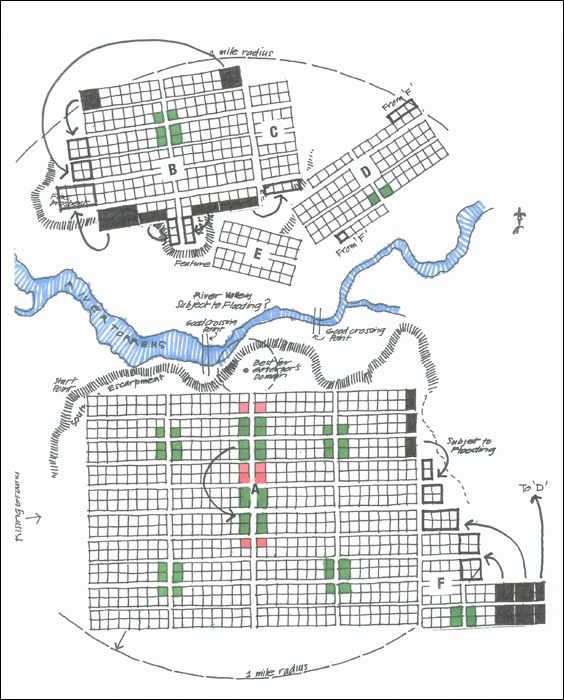
Noting where corners of the plan overlap the one-mile radius, or the escarpments, or land subject to flooding, Colonel Light sensibly snips around the edges and locates the offcuts in the most desirable nearby locations remaining. Finally, left with four allotments spare, he drops them in the north-east corner and south-west corner of part (c). He redistributes the squares and, by extraordinary coincidence, the square in part b (Wellington) has fallen in the correct spot. Just 31 cuts in total and time for lunch.
Postscript
Readers will note that Light locates public facilities – including a school, a hospital, an armoury and parade ground and sale yards – outside of the city grid in a buffer zone. They should also note that this buffer zone, which was delineated around the city by a dashed line on Light’s plan and answered his instructions for “public walks”, became the Parklands, but primarily responded to Bentham’s “vicinity maximising and dispersion prevention principle”, a critical utilitarian aspect of the economic strategy for the settlement: to create value through scarcity, brought about by containment of the availability of land.
Associate Professor Ron Danvers is a well-known Adelaide architect and urban designer, and the recipient of many national and international awards for his work in Australia and South-East Asia.