Hi-tech SA platform helps map NSW flood damage
A technique developed by Adelaide aerial mapping company Aerometrex is being used to help New South Wales authorities pinpoint individual addresses and buildings impacted by flooding this month.

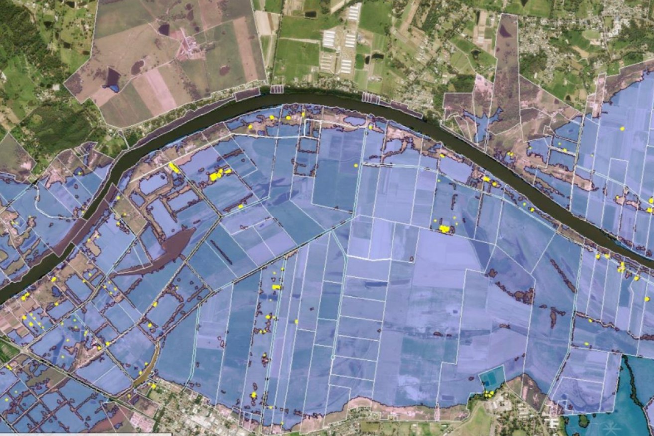
A MetroMap screenshot showing the NSW flood extents, property boundaries and individual buildings affected.
The fast- response analytics services are being used to support the NSW Flood Emergency response activities through advanced analytics of the areas flooded in NSW.
The system combines satellite imagery of the flooded areas, the company’s MetroMap platform and aerial image library and Geoscape building footprints to produce a list of property addresses and specific buildings potentially affected by the flooding.
Aerometrex says the information is vital to many organisations directly involved in managing and helping communities recover from the floods including, emergency services, councils, builders and insurance companies.
“These new capabilities harness the power and agility of the MetroMap platform, as well as third party datasets,” the company said in a statement to the ASX this morning.
“Given the immense impact of the NSW floods, Aerometrex has utilised these new capabilities to immediately support the NSW Flood Emergency response activities through advanced analytics of the areas flooded in NSW.
“In particular, these services have described the flood extents to Aerometrex’s industry and government partners in order to assist them in helping affected NSW communities recover in the coming weeks and months.”
MetroMap is an online aerial imagery subscription service with highly accurate geospatial data viewed through a web browser interface, to which Aerometrex has added 3D models.
NSW State Emergency Services received almost 10,000 calls for help and conducted 870 flood rescues during last week’s floods that forced thousands to evacuate in several parts of the state.
Aerometrex managing director Mark Deuter said the floods were an “outstanding example” of the company’s ability to provide mission-critical data in an emergency situation.
“The scale of this disaster makes it extremely difficult to identify and assist individual people who have been affected on a case-by-case basis,” he said.
“The advanced analytical techniques developed by our team and supported by our data partners provides this information within days of receiving the satellite imagery.”
Earlier this month the Glynde-based company was awarded four Queensland Government projects totalling $1.1 million, which it will begin in April.
The projects are part of the Queensland Government’s Spatial Imagery Subscription Program and include an 11,956sq km area of South East Queensland from Noosa Heads to the NSW border, a 111,126sq km section of the Galilee Basin and a 50,668sq km regional survey of North Queensland.
The announcements represent somewhat of a turnaround in recent fortunes for Aerometrex since posting a $2.9 million loss for the half-year ended December 31 in February.
Only its MetroMap subscription service showed significant growth for the period, increasing to $1.5 million in revenue compared with just $182,000 in the first half of the previous financial year.
This included contracts with Suncorp and Geoscape Australia to the digital imagery service worth at least $860,000.
Aerometrex is a 30-year-old company, which listed on the ASX in December 2019 and has a market cap of about $93 million.
However, its share price has slipped in recent weeks from $1.15 on March 1 to $0.93 at 11am today. This has coincided with its removal from the ASX All Ordinaries index on March 22.